Various location services have become a logical part of numerous applications. We're taking advantage of a GPS feature automatically, without thinking: when ordering a taxi, traveling, looking for a place to dine, etc. Businesses also consider geolocation a beneficial addition: among others, a company can send notifications to users who are in the immediate vicinity of their store, restaurant, and so on. To implement all of the above, APIs for location-based services are required.
The first thing that comes to mind is, of course, Google Maps API. And the solution is really great, with a lot of advantages. However, unfortunately, recently the price of its services has increased significantly. And now Google Maps API is too expensive.
But don't worry! There are many excellent and affordable alternatives to Google Maps. And that's something we'll talk about in our article.
Moreover, we’ve conducted a comparative analysis of these mapping tools and are ready to share its result with you.
Why use location-based and mapping solutions?
Today it's hard to imagine how people used to get by with just paper maps. Fortunately, this era is a thing of the past, and now we have GPS navigation devices and mobile applications at our disposal. Interested in augmented reality map app? Just read the linked article!
The task of the GPS feature is to detect the current location of the device and update the information as it changes. And then we can use such data as we please.
And, as we've said, it requires the help of Map APIs.
What is a Map API?
API stands for Application Programming Interface. In a simpler language, the API is a ready-made code to facilitate the developer's work. In the case of different mapping sources, it’s about getting real-time location data.
There are several sources to find out where a device is at a particular moment. And when it comes to laptops or desktop computers without a GPS chip, the location is most likely to be determined using an IP address, which reduces the result validity.
However, when dealing with modern mobile phones, the API can use information from more accurate sources, such as GPS, network connection (Wi-Fi, 3G, HSPA +), GSMMAMA cell.

Why Google Maps API is the one?
Before describing its Maps API alternatives, let's take a look at what the particular appeal of a Google solution is:
-
Maps offline. The most powerful feature of Google Maps is the ability to use maps and navigation without an Internet connection (of course, not fully and with all sorts of restrictions and limitations).
-
Street View Mode. Over the years, a Street View feature has accumulated a huge amount of panoramic shots which has made it a full-fledged service.
-
Google Now commands. In some situations, navigation can be difficult, and then Google Now (a voice assistant) will come to the rescue.
-
History of visited places. Google is constantly monitoring the history of places visited and recording every user action in the Maps application.
-
Custom maps. We mean the ability to supplement maps with routes, lines, shapes, markers, objects with a description, and the like.
-
Intermediate points in the route. Another useful feature is the possibility to add intermediate points to the built route. Therefore, the user has a chance to plan a route with several stops in mind.
-
Taxi in the routes. When building a route on Google Maps, it is possible to select a way to travel by car, public transport, bike, or on foot. Google also collaborates with some of the international taxi services and offers them to travel the chosen route.
These custom map features look great, right? But, alas, in 2018, Google decided to make Google Maps a new super-profitable business by raising prices 14 times and reducing the free use limit almost 30 times. And the company didn't care to warn its clients ahead of time, everything happened within a minimum notification period.
And although Google is sure of being right, many businesses have already started feeling the inconvenience of using its mapping tools. "Google Maps API is too expensive now!" - they keep saying.
It’s important to note that Google offers the same prices everywhere, from the USA to China and Africa. However, you see, the monetization possibilities differ significantly depending on the market.
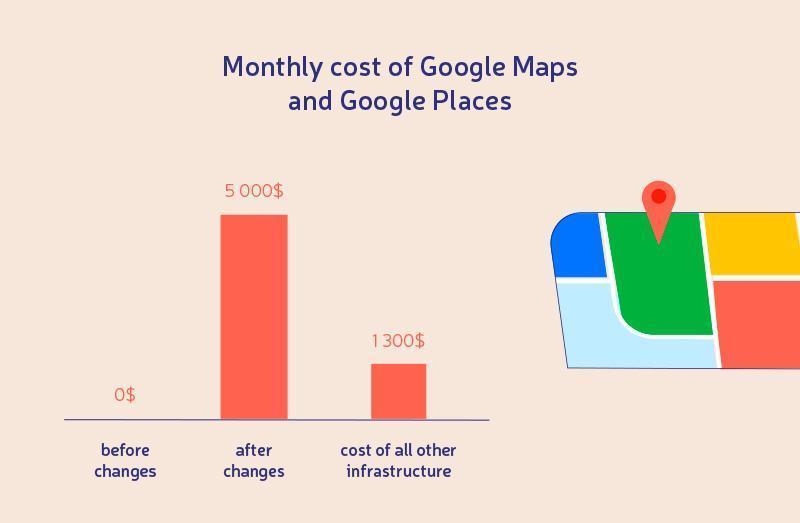
Resume: if you continue to actively and fully use Google location tools, the cost of Google Maps becomes many times higher than the previous price of the entire infrastructure. That's rather disappointing, isn't it?
Fortunately, all these problems stimulated Google Maps competitors to actively promote and develop their services.
Google Maps API Alternatives
So: MapBox, TomTom, Here, and so on... what to base your choice on?
Mapbox
MapBox is a framework, which occupied the niche of custom maps back in 2010. Two years later, in 2012, the Mapbox iOS SDK was released. Now the company is a provider of mapping and location data services for giants such as Evernote, Foursquare, The Financial Times, The Weather Channel, Pinterest, CNN, National Geographic, IBM, and Master Card.
MapBox products:
-
Maps. MapBox offers the ability to display constantly updated, really fast maps.
-
Atlas, or On-Premise Infrastructure Maps.
-
Navigation. It implies the possibility of paving routes with step-by-step instructions on the best path.
-
Search. The essence of the product is clear, right? You specify the address and get the coordinates you need.
-
Studio. This is the most interesting of the custom map features. It gives the user the opportunity to experiment with styles and create his own unique map design (with minimal effort). The Studio allows customizing many parameters including the names of geographic objects (change of font, color, transparency), colors of roads, buildings, parks, tunnels, bridges, and countries. By the way, before publishing your design, you’ll be offered to look at the final map version in comparison with the basic one.
ArcGIS
ArcGIS is another interesting alternative to Google Maps aimed at managing geographic information, including collecting, organizing, analyzing, and sharing location data. In essence, ArcGIS is an infrastructure for creating maps.
ArcGIS is the undisputed leader among mobile and web mapping services and is held in high repute. The service is especially popular in the areas of business, government, science, education, and the media.
Products:
-
ArcGIS Pro, which offers (among other things):
-
converting data to maps and useful geolocation information;
-
mapping and data visualization simultaneously in 3D, 2D formats;
-
editing and analysis of location data.
-
-
ArcGIS Online for working with intelligent styles of custom maps, manageable visualized data, and location analysis tools.
-
ArcGIS Enterprise is an improved geospatial management system. It provides more powerful functionality that, in addition to the usual features, offers such mapping tools:
-
secure and efficient multiuser deployment;
-
powerful automation tools;
-
analysis of patterns and anomalies in geodata;
-
spatial data visualization and linking of facts into a single whole to improve business decisions.
-
BTW!
ArcGIS offers easy-to-use identity management and content protection through OAuth or token-based technology.
Travel Time platform
Now let's discuss the following Maps API alternatives example - TravelTime Platform, a great solution that focuses on providing high-relevant data. Excellent results are being achieved thanks to a time-based approach to searching locations a user needs. Namely, the trip time becomes the determining factor instead of calculating the distance "in a straight line".
Actually, the TravelTime Platform has 2 key products:
-
TravelTime Search, designed to search for the specified locations (taking into account trip time and a form of travel);
-
TravelTime Analytics: a good option able to enhance your business positions (by analyzing trip time information and other location data).
Among the main mapping tools the TravelTime Platform has, we’d like to mention these ones:
-
Time map or building a time-travel area. To put it simply, the feature answers such questions as: "Where would I get during half an hour if I use public transport and start the journey right here at 10 am?" The question is just an example, of course.
-
Time filter: determination of trip time from a source point to several destinations at once (up to 2 thousand) using a one-and-only request.
-
Routing: providing the most detailed direction data about moving from one point to another.
TravelTime Platform offers free and paid use options. Although the first is useless for business purposes. Companies wishing to access detailed location analytics should be willing to pay.
TomTom
Discussing the alternatives to Google Maps, it would be appropriate to describe TomTom either. The owners of the service did their best and created an excellent product: users can study maps, find destinations, keep track of traffic congestion, and so on.
The main products:
-
The Search API. It's pretty cut and dry: the product is focused on finding a specific location (address, a certain place, etc. - see our description of direct and reverse geocoding below).
-
The Maps API. The situation is very clear too, and the purpose of the service is obvious. With the Maps API, the user can take advantage of static or dynamic maps (and they're quite accurate and precise, according to the creators of TomTom).
-
The Routing API. Using this mobile & web mapping service, one is able to easily plan and build his route. The user will receive the most accurate data based on traffic and other similar conditions and oriented to different modes of travel: by car, on foot, by public conveyances, etc.
-
The Traffic API. Of course, information about traffic is also useful when planning a route, and Traffic API is needed just for this purpose.
-
The Maps SDKs - the easiest way to integrate a TomTom product into your application (the service works with a few popular platforms: web, iOS, Android).
TomTom isn't a free map service, though if you’re satisfied with 75 thousand search transactions per month you can do without paying.
Jawg Maps
Jawg Maps is another mapping solution. Its features are diverse and useful: displaying maps, building routes, finding destination points, searching for locations, and other similar solutions. All of them are designed to simplify the work with location data.
Jawg Maps Products:
-
Maps. A user is free to create a custom map or choose one he likes among the ready-made themes.
-
Geocoding. As you'll understand after reading our article, mobile and online geocoding services imply the ability to find a certain location by its address (and vice versa).
-
Routing, that is, building the optimal route.
-
Metrics. The product provides the possibility to analyze location data.
As with the other Google Maps competitors, Jawg Maps offers different pricing plans, and it’s up to you to choose the option which best suits your needs and financial capacities.
Sygic Maps
For more than 15 years, Sygic has been actively and successfully developing the Professional Navigation SDK packages focused on GPS navigation, work with maps, and other solutions of the same kind. To date, the company has more than 2,000 corporate clients worldwide. And many of them are sure that Sygic offers the best online maps.
Sygic Products:
-
Sygic GPS Navigation. The solution offers a binding to the road algorithm, which calculates the optimal trajectory of the route based on GPS coordinates or coordinates obtained from a third-party application.
-
Sygic Travel Maps. The product is aimed at travelers who can take advantage of the universal technology of building multi-level maps with the possibility of displaying user objects and graphic elements. However, the product’s target audience isn’t limited to just tourists.
-
Car Connected Navigation & Sygic Truck Navigation. These products provide routing algorithms with traffic prediction and work with cars and trucks, respectively.
-
Family Locator. An excellent mapping solution for caring parents who want to know where their children are at one time or another and be able to communicate with them if necessary (the latter is solved using the built-in chat).
-
Speed Cameras. These cameras are a product focused on improving the quality (and therefore safety) of driving a car.
All the above products are easily integrated using a convenient API. Opportunities such as access to maps from cloud storage, advanced search, building commercial routes, optimization of car park systems, and much more are also offered.
Developers can select a map data provider for each project. The fact is that the Sygic Maps API is an open-source mapping platform working in conjunction with TomTom, HERE, OpenStreetMaps, and other services.
BTW!
Sygic provides geocoding and search capabilities based on structured and unstructured text, as well as using the self-learning auto-complete feature.
Here
These SDK packages allowing working with maps through IOS and Android apps appeared in the spring of 2016. And since then, HERE has joined the ranks of Google Maps competitors and turned into a successful map-based project being used by such major companies as BMW and Nissan.
Well, it's not surprising: the project has truly advanced functionality.
Here Products:
-
Maps, an obvious product, given the specifics of the project.
-
Geocoding and Search. Read on to understand how a geocoding tool is related to the search.
-
Routing and Navigation. Examining the map is only half the battle. Users appreciate the opportunity to get advice on the optimal route much more.
-
Fleet telematics. The product belongs to the advanced custom map features focused on high-level projects with a need in smart fleet management systems.
BTW!
Here Maps are capable of displaying 3D models of buildings, and some sights have an exact graphic image of real objects. In addition, each map scheme has a nightly version, as well as a version illustrating road traffic.
And another interesting mapping solution: the SDK functionality includes the ability to cache maps in the device’s memory. This allows users to view maps even without the Internet.
LocationIQ
Our list of APIs for location-based services ends with another great solution - LocationIQ.
The company is positioning its product as a geocoder designed to quickly and accurately determine the address by geographic coordinates.
The service would come in handy for a business in need of location alerts to monitor collaborators and logistics. It's enough to connect the service, configure the generation of reports on the indicator of interest, and the required geographical coordinates will automatically be converted into addresses from the LocationIQ database.
LocationIQ prides itself on three indicators:
-
Affordability. The pricing policy is quite adequate. Moreover, by adding the inscription "Search by LocationIQ.com" you're allowed to use mapping and location data services with business purposes in mind, not paying a fee.
-
Availability. To connect the basic map with many built-in features, all that is required is the LocationIQ account. And then the level of the service's availability will only be limited by the tariff plan (see above).
-
Scalability. Owners of the service promise that the company can safely grow and scale their project, without fear of LocationIQ being unable to withstand the increasing load.
Comparative analysis of different mapping sources
Before proceeding to the analysis of the Google Maps API alternatives, we'd like to tell you what parameters we were guided by and why.
Let's get started.
Geocoding
We guess it's time to talk about the great geocoding features we've already mentioned several times earlier in our article.
Okay, what is geocoding and why (and when) do we need it?
Geocoding is the process of transforming a description of a place (coordinates, address, place name) into its specific location on the surface of the Earth.
There are different types of geocoding, and in this case, we're talking about direct geocoding. So, direct geocoding is used to determine the coordinates by the object name or its address. The API takes into account common typos and offers several suitable options.
Through the geocoding tool, you can quickly find different types of locations:
-
attractions and sights;
-
places from the gazetteer: mountains, bridges, and shops;
-
intersections of roads, house numbers with street names and postal codes.
Reverse Geocoding
Reverse geocoding is the opposite of the technology described above and is used to determine the address of an object by its coordinates. Say, you can select the house closest to a point on the map and get its name.
Reverse geocoding tool usage options:
-
Determining the nearest address by GPS coordinates: to order a taxi, find the nearest restaurant, and so on. In fact, you can take advantage of it at any time when you need to know where you are right now.
-
Tracking route. This is helpful to many companies and their employees. Among them are sales representatives who use the mobile app to fill out reports. At the time of filling in the document, coordinates are being automatically determined and linked to a report (given the address of a particular store). Then there is an automatic comparison of the address of the store where the sales representative had to make a report with the address where the report had actually been made. If the addresses mismatch, an alarming signal should be generated.
Agree, such a mobile & online geocoding service would be useful in many cases when you need to work with the location.
Distance Matrix
Distance Matrix is a criterion characterizing the distance from point A to point B and the estimated travel time (so-called duration). And the user receives not just a naked outline of facts about distance and duration metrics, but advice on the optimal route (given the existing conditions).
Directions
This is another parament that helps travel planning. It all looks like the situation with the above item. Only it's not about duration and distance, it's about directions (provided the method of movement, points of departure and destination, the number of turns, and other similar parameters).
The task of Directions (as well as Distance Matrix) is obvious, as you can imagine. For even the best online maps would do you good only if you’re also getting a detailed recommendation on how to draw up your route to the desired location. Because let’s face it: self-study of maps cannot be compared with the capabilities of different mapping sources.
Snap to Road
Surely you’ve already dealt with situations when the maps incorrectly displayed this or that road or didn’t display at all, right? Noticed any inaccuracies in building routes? So, a Snap to Road feature is intended to solve such a problem.
Snap to Road helps to build the geometry of the road, taking into account the specified GPS coordinates that the service receives on the route. And after processing this data, the program provides you with a probable path geometry made up of points snapped to where the road seems to have run.
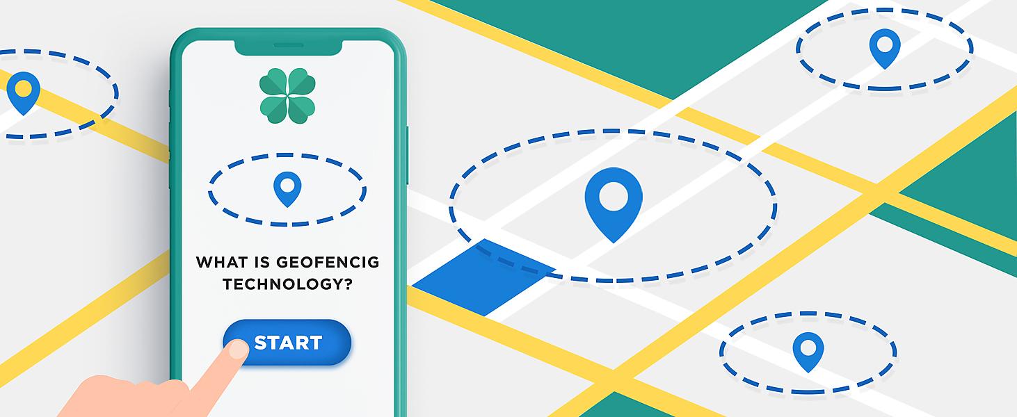
Geofencing
So, the last item on our list of various mapping tools and technologies is geofencing. What is it, in the first place?
Geofencing allows you to create a virtual zone on the map and target clients within its limits.
Unlike beacons focused on point locations (a specific store in a shopping center or the like), the geofencing technology helps you interact with everyone who is in the radius you've set. This interaction implies that while the user is in the tracking area, the application is able to perform some kind of programmed action: say, send notifications. Such an opportunity can be used by shopping centers, restaurants, and other establishments which want to communicate more closely and effectively with potential customers.

And now it's time to share with you the results of our analysis of alternatives to Google Maps. We've compiled a table that shows which services use a particular technology.
| Name | Maps | Geocoding | Reverse Geocoding | Distance Matrix | Directions | Snap to Road | Geofencing | |||||||
|---|---|---|---|---|---|---|---|---|---|---|---|---|---|---|
| sdk | api | sdk | api | sdk | api | sdk | api | sdk | api | sdk | api | sdk | api | |
| Mapbox | + | - | - | + | - | + | - | + | - | + | - | + | - | - |
| ArcGIS | + | - | + | + | + | + | - | + | + | + | - | - | - | - |
| Travel Time platform | - | + | - | + | - | + | - | - | - | - | - | - | - | - |
| TomTom | + | - | - | + | - | + | - | + | - | + | - | + | - | + |
| Jawgmaps | - | + | - | + | - | + | - | - | - | - | - | - | - | - |
| Sygic Maps | + | + | - | + | - | + | - | + | + | - | - | - | - | + |
| Here | + | + | + | + | + | + | - | + | + | + | - | - | - | + |
| LocationIQ | - | - | - | + | - | + | - | + | - | + | - | + | - | - |
Anyway, if you're interested in projects based on geolocation & mapping technologies, we're happy to offer our services. We've been working in the mobile and web development market for a long time and have huge experience.

![Augmented Reality Navigation Map Applications [Guide]](/_next/image?url=https%3A%2F%2Fd12zh9bqbty5wp.cloudfront.net%2Fuploads%2Fblog_article_avatars%2F413a31d6150710faeb9b25b2ea7c4923baecb271.jpg&w=3840&q=75)