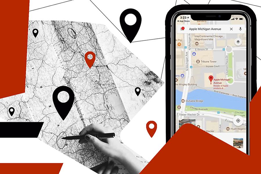
![Augmented Reality Navigation Map Applications [Guide]](/_next/image?url=https%3A%2F%2Fd12zh9bqbty5wp.cloudfront.net%2Fuploads%2Fblog_article_avatars%2F413a31d6150710faeb9b25b2ea7c4923baecb271.jpg&w=3840&q=75)
AR navigation systems synchronize Visual Positioning Service (VPS), SLAM (Simultaneous Localization and Mapping), and Global Navigation Satellite System (GNSS) data to overlay digital pathfinding onto physical environments. Modern implementation requires low-latency 6DoF (Six Degrees of Freedom) tracking and high-precision Geospatial Anchors to ensure spatial persistence. This technical analysis explores the integration of Computer Vision frameworks with mobile SDKs to solve the "last meter" navigation problem in urban and indoor settings.
What is Augmented Reality Navigation?
Augmented Reality is technology that enables integrating interactive experience, like imaginary objects to the real physical world within the real time.
The most famous and striking example is the Pokémon Go game. Playing it, the user could actually see Pokémons when he looked at his surroundings through the smartphone's camera.
But, of course, Pokemon is by no means the only object able to supplement the world around us. Routing features would also benefit from the use of augmented reality.
 Explore the Augmented Reality app development cost
The areas of AR navigation include:
-
Transportation & Urban Navigation.
-
Indoor Navigation.
-
Real-Estate AR Navigation.
-
Tourism Navigation.
Interested in cases where AR is applied? Just keep reading the guide, as we dropped some of the AR-use examples.
Technical Aspects of AR Navigation Implementation
When thinking about augmented reality map app development, you have to take into account the technical elements that ensure the functionality of AR-map applications.
iOS: Implementation of AR Navigation
The core framework for iOS AR navigation is ARKit, as it enables the development of AR experience on iOS devices. This framework operates tools for understanding the environment, track motion, and scene processing.
Key Features:
-
The feature of plane detection decodes horizontal and vertical planes for maintaining navigation overlays.
-
Anchor placement promotes placing virtual objects in alignment with real-world locations.
-
Location Anchors (ARKit 4+) applies geospatial tied to GPS coordinates for navigation.
-
The feature of scene understanding detects and interacts with surfaces.
The Tools and Libraries Involved:
-
RealityKit promotes an alleviated AR setup for interactive scenes.
-
SceneKit promotes advanced 3D rendering.
-
MapKit is applied to intertwine maps with augmented reality navigation when it comes to location-based overlays.
-
ARLocation is an open-source library that is applied to iOS AR navigation and utilizes geospatial data.
Android: AR Navigation Integration
The key framework for the implementation of augmented reality in navigation map applications is ARCore. As Google’s AR development platform, ARCore ensures motion tracking, understanding of the environment, and estimation of the light.
Key Features:
-
Understanding of the Environment. By detecting the surfaces like floors & walls, the framework places AR content.
-
Geospatial API. The framework assists in utilizing the real-world geographical data of locations to place AR content. You might be interested in location-based services API. Just read the linked article.
-
The feature of motion tracking promotes AR’s seamless followership of the user’s movements.
-
Cloud Anchors promote multi-user AR navigations (with shared anchors).
The Tools and Libraries Involved:
-
Sceneform (3D AR) alleviates the ARCore development.
-
Mapbox AR SDK intertwines ARCore with navigation elements for further mapping.
-
Google Maps SDK for Android embeds map-based navigation for the AR applications.
-
ARCore Extensions implies integrating geospatial anchors for real-world location-based augmented reality.
Cross-Platform Libraries
Building AR navigation solutions is cost-effective if applied cross-platform frameworks and libraries that will support both iOS and Android.
Unity & AR Foundation
AR Foundation is a Unity-based cross-platform framework that supports ARKit and ARCore. Unity can be implemented to build AR experiences due to the advanced 3D physics.
Vuforia
Vuforia is an AR SDK that supports iOS and Android. Its prominent features comprise image recognition, tracking of surface, etc.
Although we discussed the technological elements required to build the AR navigation map platform, you might dive into the cost to develop augmented reality app.
Advantages of Using AR Navigation Solutions
The benefits of using augmented reality for routing might seem obvious, but we’ll describe them anyway (at least, key ones):
-
Tourist Interest. Using mixed reality, one is able to arrange cool city tours. Say, if monuments or historical buildings come in sight of the person taking advantage of the augmented reality app with a routing feature, the system displays information about the particular cultural site: a brief description, photo and video materials, etc.
-
Time-Saving. Also, applications with augmented reality navigation features help to pave the best possible route to the destination. Moreover, such programs can provide data on traffic jams in a real-time mode (drivers would appreciate it).
-
Security. The most advanced programs increase driving safety (again, it would be interesting for users at the wheel). To do this, the application must work in conjunction with a special technique that scans the surrounding space and measures the distance to objects within eyeshot (in order to be able to give a timely signal if needed).
-
Improved Accuracy. By implementing GPS and geospatial mapping augmented reality provides the user with precise mapping results on direction.
-
Enhanced User Experience. This AR advantage implies integrating real-time visual elements onto the layer of the physical world, which creates an engaging way of interaction for the users within the complex environment.
Augmented Reality GPS navigation in action, so to say!
 Interested in AR/VR app development? We're happy to provide you with the mobile solutions you need!
Examples of Using Augmented Reality Navigation
Augmented reality navigation (Android, iOS) can be used to improve (and make more effective) a variety of solutions, such as:
City Navigation
The simplest and most obvious case is when a person finds himself in an unfamiliar area and tries to build the route to the final goal. Such apps based on AR places maps are meeting the needs of both pedestrians and drivers (a user just needs to clarify in advance the trip format: by car, public transport, on foot, etc.).
Shopping and Entertainment Centers and Malls
The client visiting the shopping and entertainment center can orient himself more easily if he has an AR navigation app that suggests to him what and where is located.
Museums and Exhibition Halls
Modern Android and iPhone augmented reality apps are able to determine the user's position and provide the widest overview of information regarding the object to which he directed his smartphone’s camera.
Industrial Facilities and Educational Institutions
It all goes in a similar way: the augmented reality GPS apps help to better navigate a particular institution, whether it is a factory or a university complex.
Logistics
Augmented reality navigation features would also do you good if you need to improve your logistics: let's say when it comes to visual orientation along a route.
Emergency Routing Apps
Emergency routing apps are being widely used for unforeseen cases: they warn of a nearby incident or help to make an emergency call if something bad has happened to the user himself (and he is not sure where he is right now). Of course, such emergency programs would greatly benefit from the augmented reality feature.
Advertising
By using an augmented reality experience, you can achieve the desired goal: users would see the corresponding ad flashing in front of them if they target their smartphone camera at your store (with the active AR navigation app, of course). So, this is a great way to earn money or promote your brand (depending on who you are: an app owner or someone willing to popularize his shop, pharmacy, whatever).
Examples of AR Navigation Apps
Well, now let's talk about specific examples of implementing AR and VR solutions in the navigation apps for Android and iOS.
Apple and AR Navigation Solutions
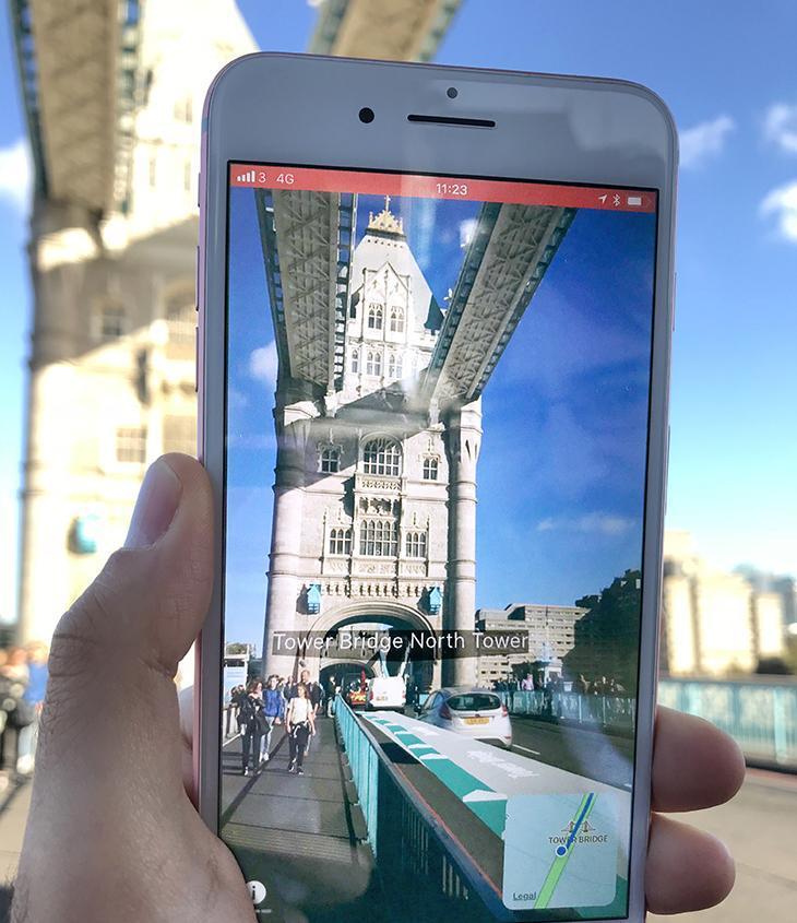
With the release of iOS 11, owners of the newest models of iPhones got access to applications built on ARKit - a toolkit which simplifies the process of working with augmented reality.
Moreover, it is now possible to navigate the area using augmented reality. You need to do the following: first of all, run maps in iOS (11 and higher) and make sure you see the blue dot. Now you have to specify the address, and the application will build the route. Next, you should click "View in AR" to call the locator and the image from the camera.
ARCity
ARCity's augmented maps (available in more than 300 cities) offer an excellent opportunity to get information about nearby sights and streets. ⠀
The application works in a really simple way: the user gives access to the camera and gets a chance to look around and find the shortest path to the place he needs. The system is able to explore surroundings, choose the best routes, and even guide the user through difficult territories. In addition, the program has a built-in compass and therefore would come in handy during the hike.
One last thing: the application is created using the ARKit tool described above.
Augmented Reality Navigation in Yahoo Maps
About a year ago, the Japanese office of Yahoo updated its iOS maps by adding the AR mode to them. So today Japanese users can take advantage of the iPhone augmented reality app with real view navigation.
The developers creatively approached the idea of integrating computer graphics into a physical environment and used the excellent tool we’ve described earlier (ARKit).
It looks really cool; see for yourself:
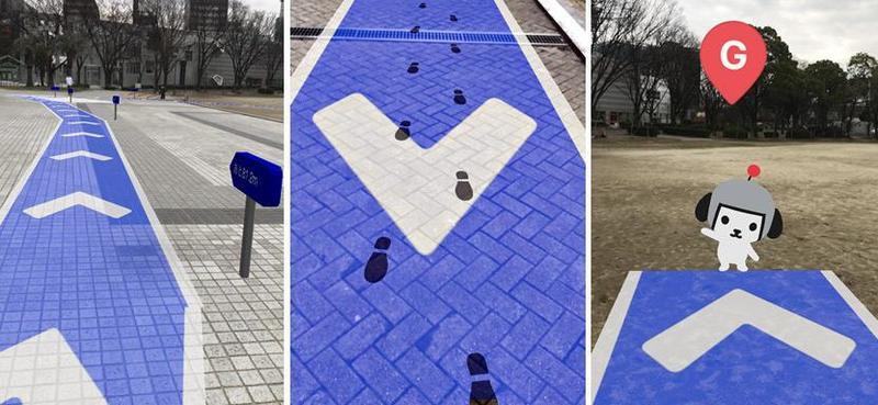
The user leaves traces (or footprints) and sees marks with the indication of the distance. In addition, along the way, he is being entertained by a Kensaku puppy, the talisman of Yahoo! Japan. This AR routing application seems to be one of the cutest augmented reality navigation apps.
The described augmented reality feature works only in Japan (with local maps) but, of course, it's just a start. Undoubtedly, Yahoo will do its best to improve the AR experience throughout the world (and, thus, attract more users to its GPS navigation application).
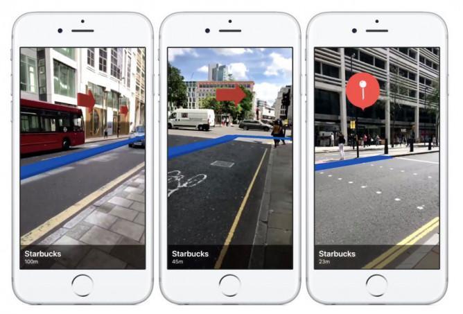
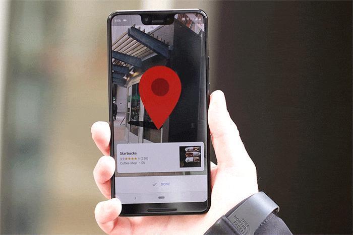
Google Maps & AR Navigation
And in conclusion, we’d like to discuss a topic that has recently been on everyone’s lips: Google Maps and augmented reality navigation. The fact is that Google is now actively testing augmented reality for routing needs.

The user location is being usually determined by GPS. Though when dealing with close city development, we cannot be sure that such a method will give an accurate result. To solve this problem, the company decided to take advantage of the camera and implement augmented reality user experience.
The service already knows the approximate coordinates and now define them more exactly by comparing the image with photos from the Street View database. While the user is moving along the route, his Google GPS navigation app displays tips imposed on the real world. These tips look like arrows indicating directions.
To avoid all sorts of collisions and other unpleasant situations, Google warns people that they shouldn't walk the streets without taking their eyes off the screen: shortly after launching the AR mode, a warning appears, and if there is no reaction following, the screen brightness automatically decreases.
The Google Maps team notes that they tried different versions of AR tips. One idea was to add a virtual character (he is also the guide), but there was a danger of users looking at the smartphone all the time (as we've said, the company seeks to avoid such problems). For now, the developers have chosen the arrows as a tips format, but the situation can change.
The new augmented reality feature for Google maps has been tried by The Wall Street Journal columnist named David Pierce. According to him, the AR mode is especially useful when starting navigation, as it allows you to immediately determine the right direction.
The Google Maps team notes that they tried different versions of AR tips. One idea was to add a virtual character (he is also the guide), but there was a danger of users looking at the smartphone all the time (as we've said, the company seeks to avoid such problems). For now, the developers have chosen the arrows as a tip format, but the situation can change.
Future Prospects of AR Navigation
Augmented reality map apps gain popularity due to their seamless operation and alleviated process of route tracking. Nevertheless, this type of app does not only suit for civil navigation, real estate tours, etc. Have you heard about AR navigation in healthcare? We’re going to discuss the future of augmented reality.
Healthcare 3D Mapping
AR is at its peak of development, as it touches on the versatility of industries. For instance, in healthcare, the 3D rendering of hearts implies that AR contributes to the creation of the three-dimensional echocardiogram, which maps the connection between the valves and large vessels connected to the heart.
Integration with Real-World Information
This prospect implies that the user will not utilize the application only for route tracking but will be able to get the results directly on the go while searching for nearby locations. The Interactive Points of Interest (POI) system will provide the client with real-world results on the nearby locations of interest, like cafes, restaurants, etc.
Multi-User Collaboration
Multi-user collaboration implies the possibility of group navigation. The augmented reality map app will enable users to share their navigation to build a collaborative route.
Hence, the future of AR-based map applications is going to revolutionize the user experience as well as contribute to healthcare-relevant navigation.
Summary
In this article, we discussed AR-based mapping applications, showing their advantages, case examples, and advantages. The key benefits of the identified type of applications are tourist interest, time-effectiveness in best route crafting, security, enhanced accuracy, and streamlined user experience.
We'll do what seems best in your particular case and create a new AR map app from scratch (if you don't have an AR-based navigation application yet).
 Have we convinced you to implement AR Navigation? Then looking forward to hearing from you.